How is APC planning for Acadiana’s future?
The Acadiana Planning Commission has set a priority on community planning services in order to prepare the area for future growth. These community planning services include direct support to smaller communities in an effort to work alongside economic developers and governments to build capacity and focus on their strengths.
What types of community planning services are available?
The Acadiana Planning Commission provides assistance with GIS Mapping, securing grant funding, educating communities on land use, and other improvement initiatives. The goal of the APC is to make support available so that when a community needs support they have it.
Learn more about APC programs and initiatives by following the link here.
Community Planning
I-49 Midway
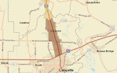
The Interstate 49 Midway Corridor is a multi-phased project designed to create opportunities and spur economic growth along I-49. The corridor both abuts and encompasses parts of Washington, Opelousas, Sunset, Grand Coteau, and areas of unincorporated St. Landry Parish. In February of 2019, APC applied for and received a $30,000 USDA Rural Business Development Grant (RBDG) for a project titled the “I-49 Midway Corridor Strategic Growth Initiative.” APC subsequently entered into a planning services agreement with St. Landry Economic Development (SLED) to further supplement the work of the initiative. Phase I of this project was completed from April 2019 to February 2021. As a product of Phase I, the I-49 Midway Corridor Strategic Growth Initiative Report was produced, and a GIS web application was established which inventories the existing infrastructure assets along the corridor. Following Phase I of the project, APC applied for and received a second $30,000 USDA RBDG grant. The USDA deliverable for this grant is to develop a performance-based land use model along the corridor which will harmonize with all existing zoning and subdivision regulations and will be most effective where no previous codes exist. The performance-based land use ordinance being developed for the I-49 Midway Corridor is modeled after the existing performance-based land use ordinance that was previously established in Carencro and will be used to guide land use and development towards the best and highest use throughout the corridor. The land use model has been developed and is currently under review, with the next step being implementation through each jurisdictions council.
No results match your search.